2016/12/20 Author:Urban China
Think globally, act locally.
The initiative Urban China Glocal Insights Panel launched
on Dec.9, 2016.
Four speakers from Serbia, Jamaica, Afghanistan and
Ecuador, two mentors from the Netherlands and China with enthusiastic audiences
discussed on the common phenomenon that is happening around the world: “Migration
from rural areas to cities”.
Urban China edited the context for you review.
Mentors
Harry den Hartog
Founder of Urban Language,Faculty member of Tongji University
CAI Yue
Associate Vice President of CallisonRTKL Architectural Design Consulting Co.,Ltd


Speakers

Jelena Milic
From Serbia, PhD candidate, Architecture, Tongji University
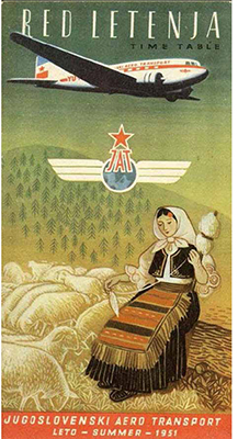
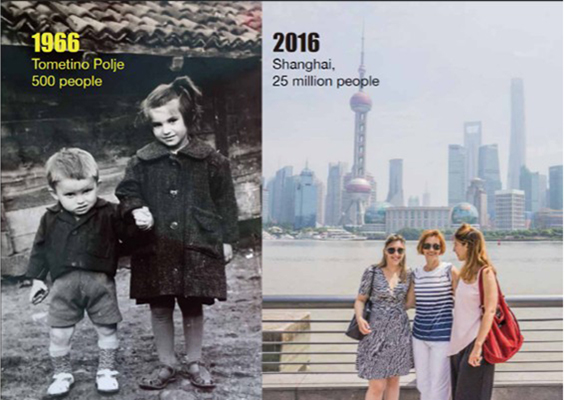
Serbia, maybe Chinese are familiar with the country, as it was part of the big socialist country until 1990s. Does everybody here think we are in EU? Well, we are not officially in EU. The population is around 8,812,000, and will reduce by 50% in 2100. The projection is not very optimistic. Some regions (rural areas) in the country are also facing the same problem as everybody is gravitating towards bigger cities. Our story of the migration from rural to urban areas is connected to the political history of the country. So I have to talk about politics for a better understanding. Before the second world war, Serbia was a socialist and mostly agricultural country. People usually lived in rural areas. Only maybe 10% lived in cities. After the War, the country became one part of a bigger story, a bigger country called Yugoslavia. The plan for our country was to become the centre of heavy industry. It means that people should remove from rural to urban areas. It was not truly their own choice but it was the only choice they had. Because all industrial elements and money were going into the cities to build the heavy industry centers. New housing productions showed up in cites as well. We called the buildings dormitories as people working in factories went there just to sleep. It is a poster from that time: one airplane up and a woman knitting with her sheep. In 1980s, people started to enjoy modern life in cities and modernism architecture showed up then. Nobody stayed in the villages as they already gave their best to cities. In 1990s, when hyperinflation came we faced the redevelopment of the economy. So from 1950 to 2000, in 50 years, 8 million people moved from rural to urban areas. In Germany this migration may last much much longer. So people have time to get used to city life. Now in 2016, villages are completely empty in Serbia. They are called centers of the retired as only people over the age of 70 live in villages. Industry completely stopped there. So what is the future? Some people say young people may come back to villages for some modern production but some doubt that. To me, I would like to finish with the image of my mom. She was born in a village and moved to the city for school. In 2016 she came to Shanghai to visit me. I would like to connect all this to urbanization and globalization because you never know what will happen, right?
 |
 |
 |
 |
|
|
Poster of Serbia after WWII |
Pictures of Jelena’s Mom in 1966 and 2016 |
|
Q & A
Harry: I am curious whether Serbia has any inflows of refugees?
Jelena:Most refugees want to go to countries where they can get help but our country can not provide any kind of plans for them. So basically it’s just transfer area.
Audience:I just wonder how government try to do something to stop the declining of the rural area.
Jelena:There is no clear strategy. One of the measures is that young couples can just spend a little money to live in houses there. But it is not a popular trend as the infrastructure is not good enough.

Garfield Wayne Hunter
From Jamaica, PhD candidate,
Urban planning, Tongji University
My presentation will give basic information on Jamaica including geographical situation, urban-rural migration overview, factors causing rural-urban migration, consequences of rural-urban migration and a case study of Kingston, the capital.
Not everyone here know where Jamaica is. It is located in the center of America, 4hrs from NY, 9 hrs from London and 15 or 16hrs from China by flight. It became independent from Britain in 1962. Lots of our towns were planned by the British or Spanish, while most people live in the rural areas along the coast. To talk about the urban planning in Jamaica briefly, the planning system came from Britain. If you are selling a house, you have to submit an application to get a permission. With respect to urban and rural development, strategies outlined in National Outcome #15 include: 1) Ensure that development decisions are guided by a spatial planning framework; 2) Accelerate the implementation of strategic regional centers which will play an integral role in balanced rural urban development; 3) Align with the Vision 2030 National Development Plan to ensure that spatial link between development objectives and investment decisions will be made. 4) And there are three main factors causing rural-urban migration: 5) The underdevelopment of rural sectors in comparison with urban. 6) Lack of a strong peasantry system in Jamaica, capable of keeping small farmers committed to agriculture. 7) Prevalence of poverty within rural areas and inequality in national development. This picture shows that everybody was moving to Kingston because that was the major area. People also go into Montego bay at the top or Ocho Rios because those are tourists centers. You will find opportunities within them. Tough the salary is not so decent but it is a salary, it’s an income. But then what happens to the rural communities? How can we curb rural-urban migration in Jamaica? 1) Set a national context for spatial planning at the local level: it will improve governmental capacity to formulate, coordinate and implement integrated rural development policies and programs in order to address spatially unbalanced development. 2) Optimize the use of land and natural resources by providing a framework for making sustainable locational choices. 3) Inform strategic infrastructure policy and public investment decisions which support the achievement of balanced regional development. 4) Social and physical infrastructure interventions coupled with informal settlement revitalization 5) Land regularization and improvement of tenure status. 6) Improve rural subsistence sector- formation of cooperatives as a means of self management and for effective marketing. 7) Establishment of basic social, economic infrastructures and productive capacity such as health, education, sanitation and housing. 8) Provision of credit facilities- for financing new rural production units ,establishing micro-enterprises, microfinancing. 9) Decentralization to local authority and community level rural economic development and diversification. 10) Urban service centres for rural areas to curb lack of access to basic infrastructures.
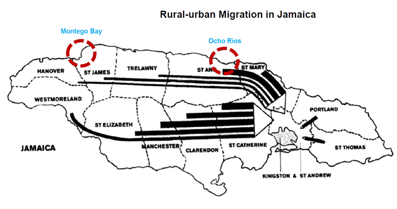
Migration to Kingston, MontegoBay and Ocho Rios,By Gerorge L.Beckford,Kari Levitt

Safiullah Rohani
From Afghanistan, Master student,
Architecture, Shanghai Jiaotong University
First, I will tell you about Afghanistan which is a neighbour of China. Afghanistan is also close to Turkmenistan, Uzbekistan, Tajikistan, Pakistan and Iran. With a total area of 652,684 km2, It has 34 provinces and the population is more than 33 million. Afghanistan got its independence in 1919. The capital is Kabul. The religion is Islam. We have many languages, but the common languages are Dari and Pashto.
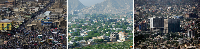
The first problem is the increasing population of Afghanistan in recent years. The population I showed you before was 33 million. It is actually not exact because the government cannot estimates the exact number in these years for reasons of wars, or maybe migration. The three biggest cities of Afghanistan, Kabul, Heart and Jalalabad, have more people than other cities. Why? The answer is the flow of migration which is above 40% in these three cities. In 2014, the Ministry of Urban Development of Afghanistan carried out one survey “Why migration from rural areas to cities?”exactly in the three cities that I mentioned. The capacity of Kabul is 2 million, but the population of Kabul nowadays is 6 million. It means the facilities including transportation and drinking water for 2 million people are shared by 6 million people now. And also in Heart, the facilities are for 1 million people and nowadays there are 3 million. In Jalalabad facilities for 2 million are shared by 3.5 million. The density is high. In Kabul is 450 person/km2, Jalalabad 230 person/km2. In Heart, the number is 400 person/km2. I will propose several reasons that I know: 1) Lack of educational institutions. Unfortunately, we don’t have high schools or universities in rural areas. 2) Lack of facilities for transportation, hospitals and entertainment. 3) Drought and famine. Afghanistan is a mandarin country with dry weather. So the land in rural areas are not that productive. 4) Lack of work and security. 5) Greed and need of city life. The Ministry of Urban Development of Afghanistan surveyed on 1,000 people migrated from rural areas to cities and got some statistics on their age and educational background. 54% of them are from 15 to 30 years old. It means cities, maybe the facilities, cinemas, parks attract young people more than the old ones. Most immigrants are of non-education. The last question to them was the plan to settle in the cities. 55% wanted to settle in the cities. When they migrate to the cities, it’s their dreaming life. What are the dreams of migrants? There are three main factors. The first is education. Maybe primary or higher education. The second is learning skills. More than 70% migrants get new skills in cities. The last, work and earnings. There are problems in the cities. The first one is environmental problem, like carbon emission, sewerage system and unpaved roads. The second is the limited transportation facilities. We don’t have any highway or subway. We have public transportation but it’s crowded. If you want to move from one place to another especially in Kabul city, it takes two hours because of the traffic jam. Another thing is the lack of drinking water and high price. The material cost price, house rent and transportation cost, lead to high living cost in the city.
Q & A
Harry: In China and also India, theybuilt new towns near cities to accommodate migrants. Do they also do this inAfghanistan??
Rohani:Yes, but most people want to migrate to the main city, we say the CBD.

Veronica Lorena Andrade Sierra
From Ecuador, Master student,
Architecture, Shanghai Jiaotong University
Ecuador, is located in South America, next to Columbia in the North, and Peru in the south.It is estimated in 2020, 64% of the population in Ecuador will live in cities.
I will focus on the city Quito, the capital. It’s located in the north. According to the Ecuadorian Institute of Statistics Censuses, the population of the Metropolitan District of Quito has multiplied seven times in the last 60 years.
The expansion of urban structure of Quito has led to changes in the morphology of the city. Places of concentrated activities and services in different scales emerged due to the changes. It’s really important to be clear that we have the different space in cities: the expansion areas. I will analyze the causes and effects of the morphological changes that have been experienced in the city of Quito due to its territorial expansion because of rural migration and internal movements of people from other cities toward the Ecuadorian capital. That’s also the reason that Quito is considered to be an intercultural city. It’s the capital and they can find more opportunities for life.
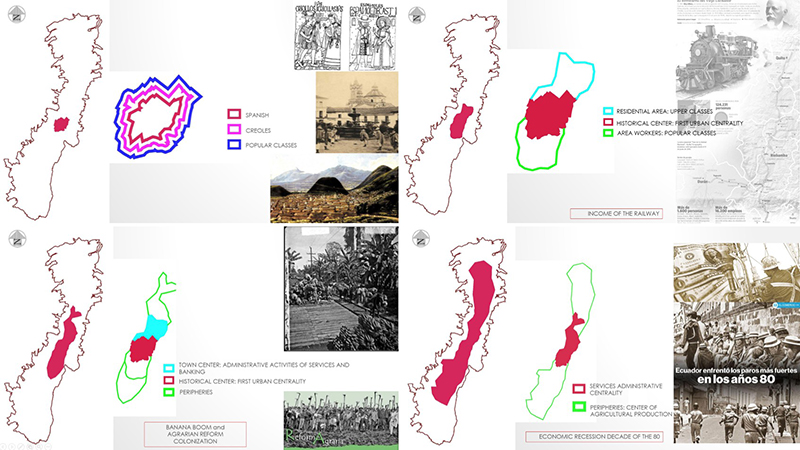
This graph shows how Quito was at the beginning.The red circle was for Spanish people. Around the Spanish people were Creoles, mixed with Indian and Spanish. The outside one were for popular classes of Quito. Then the railway changed the city. The north was residential area. In the south, workers built the train station. The south of Quito became industrial, with residents too, but mostly were immigrants. From 1960s to 1970s, the banana boom and agrarian reform colonization brought commercial movement and development to Ecuador. Until now, we export banana to all the world. It also changed a lot on the development of the city. The city continued growing and immigrants from other cities or the rural areas lived in the peripheries. It’s very interesting because you don’t have just a rural or urban area, you have this kind of mix. That’s just called periphery. It could be called city, too. The new concept “rural-urbanism”could be seen so clearly in my city.
# Context in China #
Harry: The migration in China is in a very massive scale. To all four of you being in China, what do you think of it? What about the differences between your own country and China?
Jelena : I would say China has very intensive investment into industries keeping towns remaining to be centers. The villages are undervalued. We had that problem in villages in 1990s. When industry stopped, everything stopped. I don’t know how much China has invested in the villages, also the plan for the village, the plan for the agriculture.
Garfield: In terms of that, I want to explore more about the diversification of the rural economy in China. I’m not sure what is the dynamics of the rural population, is it more agricultural in China? That’s something I want to know more.
Rohani: Every area was rural area. So it’s coming later. Urbanization comes later. I think it’s also about the definition of urban.
Harry:Yes, the definition of urban. Urban doesn’t mean density, or access to services. In my home country, the Netherlands, there’s a very high percentage of urbanization. A very small town, with 10000 or 20000 inhabitant, we call it urban. From that you can go for facilities and services by car.
CAI Yue:I think this topic is very big. We can’t make very easy conclusion. It always has two sides, positive and negative. We heard a lot of negative impacts for the immigration from rural area to the urban. The urbanization is also a good thing. Like in Shanghai, lots of people move in and make contribution to the city and produce lots of revenue. With that, we have more investment, modern facilities, utilities and infrastructures. That’s the positive side. It just depends on how you control the urbanization.